 Tanifuji Urban Planning Practice
Land acquisition decisions often begin with commercial assumptions: location, price, access, development yield, and a target schedule. Before those assumptions become binding, the site should also be reviewed as a planning and regulatory proposition.
The central question is not simply whether land can be purchased. It is whether the intended use can be lawfully established, at the required scale, within a realistic approval pathway and schedule.
Begin with Taiwan's current land-use control framework
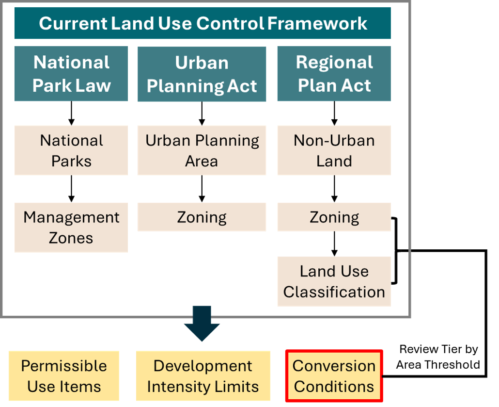
Taiwan's present land-use control framework distinguishes three legal systems: urban land, non-urban land, and national parks. The applicable system determines the governing plan, the type of zoning or classification to examine, the competent authorities, and the procedure for any proposed change.
Urban land
Land inside an announced urban plan is governed by the Urban Planning Act, the applicable main and detailed plans, and local land-use control rules. Due diligence should confirm the zoning designation, permitted uses, development intensity, building coverage, floor-area ratio, setbacks, public-facility reservations, and any special district or urban design requirements.
A proposed use that is not permitted may require an urban-plan change rather than a routine building or business approval. That distinction can materially alter control over timing and outcome.
Non-urban land
Land outside urban planning areas is presently controlled under the Regional Plan Act and the Regulations on Non-Urban Land Use Control. The legal record generally contains two linked layers:
- the land-use zone, such as a special agricultural zone, general agricultural zone, industrial zone, rural zone, forest zone, scenic zone, or designated-purpose zone; and
- the land-use classification assigned to an individual parcel, such as agricultural and pastoral land, building land, transportation land, water-conservancy land, or land for a designated-purpose enterprise.
The zone provides the wider spatial policy context. The land-use classification identifies the parcel-level legal use category. Both must be read together with the permitted-use schedules, development intensity rules, environmental constraints, and conversion requirements.
National parks
Land within a national park is governed by the National Park Act, the relevant national park plan, and its management zones. A parcel that appears geographically similar to surrounding rural land may therefore be subject to a different statutory system and a substantially more conservation-led decision framework.
Account for the transition to the National Land Planning Act
The National Land Planning Act is already in force as a planning statute, and national and municipality or county land plans have been announced. The operational transition in land-use control depends on the announcement of local national land functional zoning maps.
Following the January 2025 amendment, those maps are to be announced within ten years after municipality and county land plans. The current statutory schedule therefore extends the transition to no later than April 30, 2031. Under Article 45, the Regional Plan Act ceases to apply from the date the relevant functional zoning maps are announced.
For an acquisition with a long development horizon, due diligence should therefore record both the current legal status and the site's anticipated treatment under the emerging national land planning framework. A conclusion based only on today's non-urban zoning may not be sufficient for a project whose approvals or construction will extend into the transition period.
Test the intended use, not only the land label
A land certificate or zoning map is a starting point, not a feasibility conclusion. The review should translate the proposed project into the legal questions that the competent authorities will ask:
- Is the intended use listed as a permitted use or a permitted-use detail?
- Is a business establishment plan or sector approval required?
- Can the existing land-use classification support the facility, or is conversion required?
- Does the development area trigger a land-use zone change or development permit?
- Are access, utilities, drainage, buffers, or public-facility obligations capable of being satisfied?
- Do agricultural, environmental, water, coastal, cultural heritage, national park, slope-land, or disaster-prevention controls apply?
The same parcel may be workable for one facility configuration but not another. Feasibility should therefore be tested against a defined footprint, use, capacity, access strategy, and project schedule.
Distinguish the land-use approval from sector approval
Taiwan's approval system is distributed across land-use authorities and competent authorities for the relevant business. A land-use authority determines whether the proposed use is consistent with planning and land-control rules. The sector authority examines whether the project itself is necessary, reasonable, and compliant with the law governing that industry or facility.
Depending on the project, the sector authority may be responsible for energy, industry, transportation, agriculture, water, tourism, social welfare, or another policy field. Environmental impact assessment, water and soil conservation, drainage, coastal management, cultural heritage, and building approvals may add separate review tracks.
An approval matrix should identify each authority, the legal instrument it issues, whether reviews may proceed in parallel, and which approval is a prerequisite for the next step.
Review the site as a stack of spatial constraints
Planning status should be combined with cadastral and spatial evidence. At minimum, early-stage review should consider:
- parcel boundaries, ownership pattern, and cadastral fragmentation;
- legal and physical access;
- urban zoning or non-urban zone and land-use classification;
- agricultural land quality and agricultural production context;
- environmental sensitivity, hazards, slopes, water resources, and conservation areas;
- existing infrastructure and utility corridors;
- neighbouring uses, buffers, and potential community interface; and
- the cumulative area of adjoining or functionally integrated project parcels.
GIS overlays are useful because many decisive conditions do not appear in a single land record. They also help reveal whether a proposed boundary has been drawn around the legal problem rather than around the functional project.
Record uncertainty before commitment
Good due diligence does not force certainty where the evidence is incomplete. It should distinguish:
- conditions confirmed from authoritative records;
- interpretations that require written consultation or agency confirmation;
- design changes that could mitigate a constraint;
- approvals with discretionary or public-review elements; and
- unresolved issues that should become transaction conditions, risk allocations, or reasons not to proceed.
The practical output is a decision record: what is permitted today, what must change, who decides, what evidence is still missing, and which assumptions should not be relied upon until confirmed.